When you click on links to various merchants on this site and make a purchase, this can result in this site earning a commission. Affiliate programs and affiliations include, but are not limited to, the eBay Partner Network.
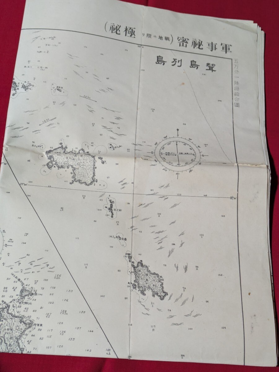
Description1944 WWII Imperial Japanese Army General Staff — Secret Military Map of Iwo Jima and the Ogasawara Islands — 1:50,000 — Original Wartime MapAn original Japanese military map dated 1944 (Showa 19), issued by the Imperial Japanese Army General Staff during the final phase of World War II.This large-format map, measuring approximately 109 × 78 cm (42.9 × 30.7 inches), depicts Iwo Jima and surrounding islands, including North Iwo Jima and South Iwo Jima.Most notably, the map bears an official Japanese military secrecy designation and identifies the Imperial Japanese Army General Staff as the issuing authority.Published in 1944, just one year before the famous Battle of Iwo Jima, this is an extraordinary historical document from the war itself.■ Original Japanese Military InscriptionsSeveral inscriptions printed directly on the map are particularly important.Upper Right: “Military Secret (Top Secret in War Zones).”This indicates that the map was treated as classified military material, with a stricter secrecy designation applicable in combat areas.Main Title: 小笠原群島 — Ogasawara IslandsThe Ogasawara Islands lie in the Pacific Ocean south of mainland Japan.The wider island group includes the volcanic islands associated with Iwo Jima, an area of major strategic importance during the Pacific War.Central Map: 硫黄島 — Iwo JimaThe name “Iwo Jima” appears directly on the map, accompanied by geographical and topographical information.The document also includes maps of nearby islands, including North Iwo Jima and South Iwo Jima.Lower Left Margin: 昭和十九年版 参謀本部Translation: “1944 Edition — Army General Staff.”This inscription identifies the edition year and the Japanese Army General Staff, one of the principal military command and planning organizations of Imperial Japan.These original printed inscriptions provide direct evidence of the map’s wartime origin and military purpose.■ Iwo Jima and World War IIIwo Jima is a small volcanic island located between the Japanese mainland and the Mariana Islands.During the final stages of World War II, its strategic location made it an important part of Japan’s defensive network.Japanese forces developed airfields, observation facilities, and defensive positions on the island.On February 19, 1945, American forces landed on Iwo Jima.The Japanese defenders, commanded by Lieutenant General Tadamichi Kuribayashi, resisted in one of the most intense and famous battles of the Pacific War.The battle lasted approximately five weeks and became one of the defining engagements of World War II.■ A Military Map Published Before the BattleWhat makes this document particularly compelling is its date.1944 — the year before the Battle of Iwo Jima.During this period, Japan’s military position in the Pacific was deteriorating, particularly following the American offensives in the Mariana Islands.The Japanese military was increasingly focused on defending the approaches to the home islands.This map represents the geographical information available to the Imperial Japanese Army during that crucial period.Unlike postwar reproductions, modern battlefield maps, or historical illustrations, this is a period military cartographic document issued before the battle took place.Its secrecy designation further emphasizes the importance attached to geographic information during wartime.■ Item Details* Period: World War II, 1944 (Showa 19)
* Issuing authority: Imperial Japanese Army General Staff
* Map title: Ogasawara Islands (小笠原群島)
* Principal location: Iwo Jima (硫黄島)
* Additional islands: North Iwo Jima, South Iwo Jima, and other nearby islands
* Classification: 軍事秘密(戦地に限り極秘) — Military Secret (Top Secret in War Zones)
* Edition inscription: 昭和十九年版 参謀本部 — 1944 Edition, Army General Staff
* Scale: 1:50,000
* Dimensions: Approx. 109 × 78 cm (42.9 × 30.7 inches)
* Format: Large folding military map
* Language: Japanese■ ConditionThis original wartime paper map shows age-related discoloration, folding creases, and some small tears.Considering its age, it is described as being in relatively good overall condition.Please carefully examine all photographs for details of its condition.■ Own a Piece of HistoryJapan, 1944.The Pacific War was approaching its final and most destructive phase.Japanese military planners were preparing to defend the islands standing between advancing American forces and the Japanese mainland.Among those islands was Iwo Jima.Less than a year later, the island would become the site of one of the most famous and fiercely contested battles of World War II.This map preserves a view of Iwo Jima as it was documented by the Japanese military before that battle.Printed on the document itself are the words “Military Secret” and “1944 Edition — Army General Staff.”These are not modern historical annotations. They are the original markings of a wartime military document.For collectors and researchers of Iwo Jima, the Pacific War, Imperial Japanese Army history, military cartography, and World War II artifacts, this is a particularly compelling historical piece.This is not simply a map showing where history happened. It is a map produced by the military before that history unfolded.Own a piece of history.Shipping
FedEx or Japan Post
International Buyers - Please Note:
Import duties, taxes, and charges are not included in the item price or shipping cost.These charges are the buyer's responsibility.Please check with your country's customs office to determine what these additional costs will be prior to offerding or buying.
Provided by HARU