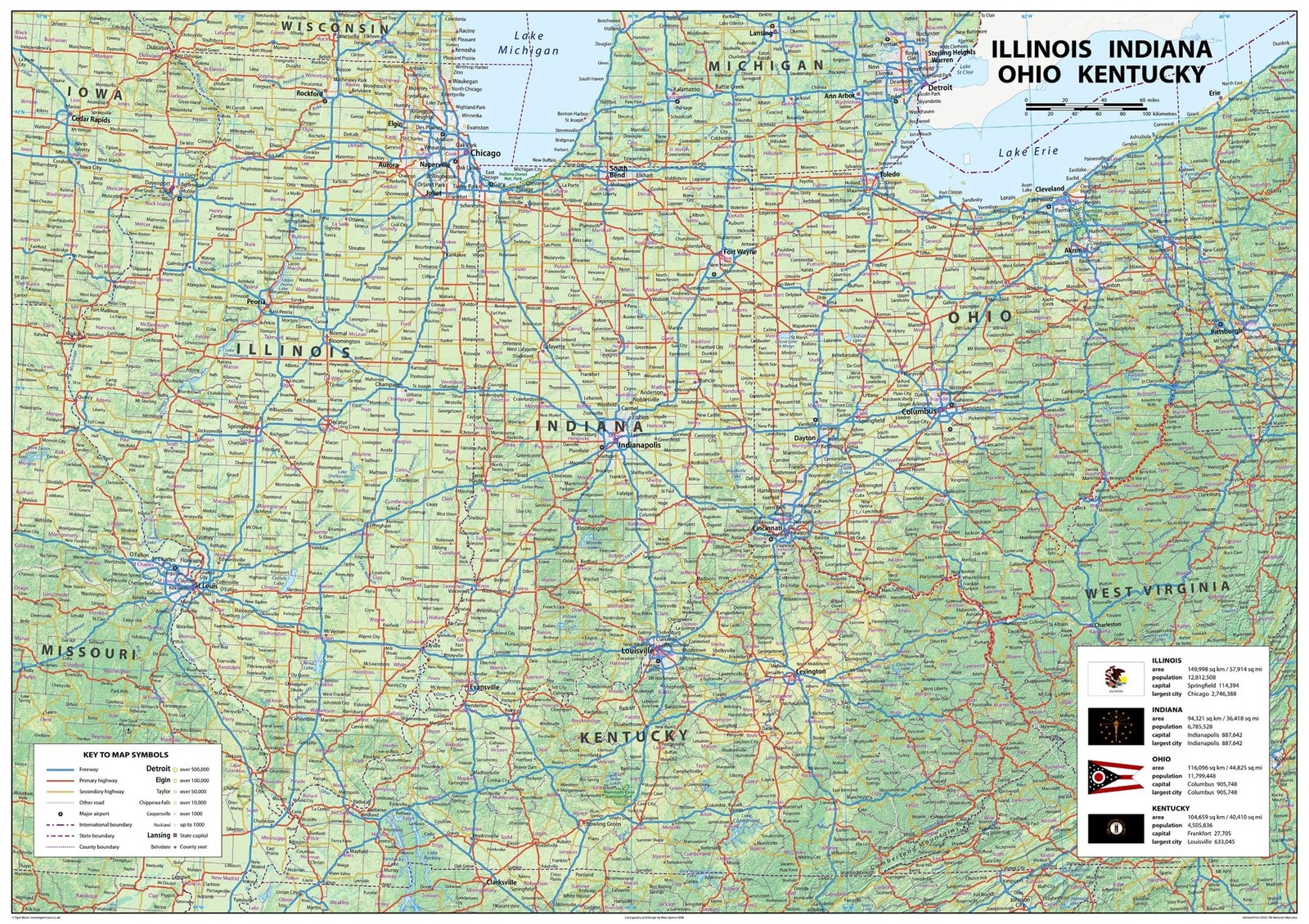
Illinois, Indiana, Ohio and Kentucky Physical Map - 23.3 x 16.5 Inches - Pape... For Sale

When you click on links to various merchants on this site and make a purchase, this can result in this site earning a commission. Affiliate programs and affiliations include, but are not limited to, the eBay Partner Network.

Illinois, Indiana, Ohio and Kentucky Physical Map - 23.3 x 16.5 Inches - Pape...:
$38.80
Illinois, Indiana, Ohio and Kentucky Physical Map - 23.3 x 16.5 Inches - Paper Laminated Product Details - Color: Blue
- Brand: Tiger Moon
- Map Type: Physical
- Paper Finish: Smooth
- Sheet Size: 23.3 x 16.5 inches
- Brand Name: Tiger Moon
- Map Type: Physical
- Manufacturer: Tiger Moon The Tiger Moon Trading Company Ltd
- Paper Size: 23.3 x 16.5 inches
- Item Dimensions L x W: 16.5"L x 23.3"W
- Color: Blue
- Paper Finish: Smooth
- Discover Illinois, Indiana, Ohio, and Kentucky with this stunning physical map, boasting remarkable insights on capital cities, size, population, and largest cities, plus airports, highways, boundaries, and population centers. Illinois is a Midwestern state, renowned for its two biggest cities, Chicago and its Metro East section of Greater St. Louis. Additional spots like Peoria and Rockford, as well as Springfield, the state's capital, join in the mix.
- Boasting the fifth-largest GDP and the sixth-largest population of the fifty U.S. states, and a 25th-largest land area, Illinois is sure to delight! Indiana, rooted in the Midwest, is the 38th-largest by area and holds the 17th-largest population of all 50 states, with its capital of Indianapolis taking the fore. Ohio, the seventh-most populous state in the US, overflows with over 11.8 million residents across 34,000 square miles.
- Home to bustling cities such as Columbus, Cleveland, Cincinnati, Dayton, Akron and Toledo, it's no wonder Ohio is a hub of activity. Kentuckythe "Bluegrass State"boasts a population of approximately 4.5 million, with its capital city Frankfort and largest city Louisville.
- Outlining the physical features of each state in vivid detail, this map makes it easier for you to identify and explore the surrounding region. From the great economic features of Illinois, the history of Indiana, the vibrant culture of Ohio, and the Bluegrass State of Kentucky, you'll find the perfect starting point for your next big adventure.
- Size - 23.3 x 16.5 Inches
- Printed onto a high quality paper and laminated for durability.
|
|
Related Items:
Lot Of 20 License Plates 4 States Illinois, Indiana, New Jersey, Pennsylvania $49.95
Fox Valley projectile point (Illinois/Indiana) arrowhead $135.00

Extraordinary 1904-1918 Photo Album-18-Family Photos-Illinois-Indiana Area $39.00
|








