

|
Site Categories |
|
Featured Items |

Poodle, Spaghetti Trim, Ucagco


|
1952 DELAWARE Official State Highway Map Wilmington Dover Governor Caleb Boggs For Sale


When you click on links to various merchants on this site and make a purchase, this can result in this site earning a commission. Affiliate programs and affiliations include, but are not limited to, the eBay Partner Network.

1952 DELAWARE Official State Highway Map Wilmington Dover Governor Caleb Boggs:
$12.99
Official 1952 highway map of Delaware, printed more than 68 yearsago. - This fold-out map opens to 30" x 18" andhas great detail on old road alignments and route numbers.
- It was published by the Delaware State Highway Department, Dover,and isdated on the cover as the 1952-1953 edition.
- There is aninset plan of Wilmington and a single-panel map locating the Delaware MemorialBridge, whichhad opened to traffic less than a year before this map was printed.
- Condition: This map is in very good, lightly used condition. There aresome faint smudges on the cover and short breaks on a a couple of the folds.There are no rips, tears, or writing. Pleasesee the scans and feel free to ask any questions.
- There are five known versions of Delaware's 1952-1953 official state highway map. This version has a rubber-stamp imprint of Governor J. Caleb Boggs on the front cover.
- Buy with confidence! We are always happy to combineshipping onthe purchase of multiple items — just make sure to pay for everythingat one time, not by SixBit's eCommerce Solution
|
|
Related Items: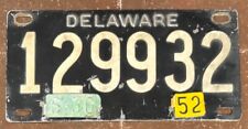
Delaware 1952 RIVETED License Plate # 129932 $179.99
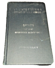
APRIL 1952 DELAWARE LACKAWANNA AND WESTERN DL&W OPERATING DEPARTMENT RULES $30.00
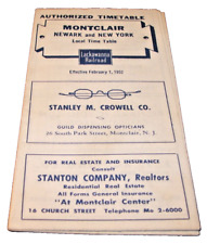
FEBRUARY 1952 DL&W DELAWARE LACKAWANNA & WESTERN MONTCLAIR NJ PUBLIC TIMETABLE $25.00
|
|
|
Shopping Cart  |

|
Recently Viewed |
|
Latest Items |
|
Facebook |
Secure Websites

|
