When you click on links to various merchants on this site and make a purchase, this can result in this site earning a commission. Affiliate programs and affiliations include, but are not limited to, the eBay Partner Network.
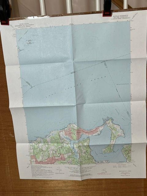
Here we have an original USGS, Department of the Interior Geological Survey Quadrangle Map. These old maps provide fantastic topographic detail, great for historical reference or research, depicting numerous landscape and cultural details. They are very colorful, rich with geographic information, and show features as they existed at the time of the original surveys.Map DetailsState = New York / ConnecticutTitle = BayvilleSeries = 7.5 MinuteMap Date = 1967Scale = 1:24000Contour Interval = 20 feetSurveyed = 1943, photoinspected 1976Printed = printed 1984Sheet Size = 27” x 22”Land Coverage = approximately 9 x 7 milesMap InformationRepresentative Civic Features = Cove Neck, Matinecock, Locust Valley, Lattingtown, Oyster Bay.Representative Landscape Features = Oyster Bay Harbor, Long Island Sound, Mill Neck Creek, Captain Harbor, Wee Captain Island, Oak Neck Beach, Plum Point.Representative Cultural Features = Sagamore Hill Historical Site, T. Roosevelt Memorial Park, Mill Neck Manor School, Horse Hollow Road, Centre Island Road, St. Johns Church.Map Condition = clean and bright; no blemishes; crisp edges and corner tips; no marks, tears or holes.Map has been folded and will be mailed in that manner. 1967 Bayville New York USGS Geological Survey Topographic Topo Map 1967 Bayville New York USGS Geological Survey Topographic Topo Map
Click image to enlarge
Description
Here we have an original USGS, Department of the Interior Geological Survey Quadrangle Map. These old maps provide fantastic topographic detail, great for historical reference or research, depicting numerous landscape and cultural details. They are very colorful, rich with geographic information, and show features as they existed at the time of the original surveys.
Map Details
State = New York / Connecticut
Title = Bayville
Series = 7.5 Minute
Map Date = 1967
Scale = 1:24000
Contour Interval = 20 feet
Surveyed = 1943, photoinspected 1976
Printed = printed 1984
Sheet Size = 27” x 22”
Land Coverage = approximately 9 x 7 miles
Map Information
Representative Civic Features = Cove Neck, Matinecock, Locust Valley, Lattingtown, Oyster Bay.
Representative Landscape Features = Oyster Bay Harbor, Long Island Sound, Mill Neck Creek, Captain Harbor, Wee Captain Island, Oak Neck Beach, Plum Point.
Representative Cultural Features = Sagamore Hill Historical Site, T. Roosevelt Memorial Park, Mill Neck Manor School, Horse Hollow Road, Centre Island Road, St. Johns Church.
Map Condition = clean and bright; no blemishes; crisp edges and corner tips; no marks, tears or holes.
Map has been folded and will be mailed in that manner.
Check out my other items at sale and in my Store!
Images sell!
Get Supersized Images & Free Image HostingCreate your brand with Auctiva\'s
Customizable Templates.
Attention Sellers - Get Templates
Image Hosting, Scheduling at Auctiva.
Track Page Views With
Auctiva\'s Counter