When you click on links to various merchants on this site and make a purchase, this can result in this site earning a commission. Affiliate programs and affiliations include, but are not limited to, the eBay Partner Network.
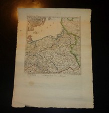
Dated January 6th, 1813 this map shows the Prussian Empire just prior to the War of the 6th Coalition in which Russia and Prussia allied to defeat Napoleon and force his abdication a little over a year later. The map appears to show the location of French Allies and Russian Allied forces and apparently the French forces are retreating after their massive defeat in the French Invasion of Russia. At this time there was a transition of allegiance as Prussia was formerly allied with France, but after the decimation of the Grand Army after their retreat from Russia, Prussia would eventually align with Austria, Russia and Great Britain to begin the War of the Sixth Coalition.
On this map you can see a green column of Russian or possibly Allied troops aligned against what I presume are French or Polish/
German Allies of the French at a town called Mehlsach (modern day Pieniężno, Poland), and they seem to retreat to Mareinwerder (modern day Kwidzyn, Poland) as the Russian troops advance to Elbing (modern day Elblag, Poland).
All said this could be historically significant as it shows the Russians had entered northern Prussia well just shortly after the defeat of the French invasion and well before the first battle at Lutzen in the 6th Coalition war, meaning that Prussia may have not had much choice but to align with the Russians for this conflict.
The map measures about 19 x 14.5 inches total with the map area about 11.5 x 10.75 inches. It is on a parchment like paper and you can tell it is hand colored showing the current boundaries of the ever changing borders of the various factions. It is currently in a rolled state and will be shipped that way.
shlf2519