You are here: Home > Maps, Atlases, Globes > Maps & Atlases
| Item Details : Antique Map Washington DC Virginia 1912 For Sale |
Rate This Item
|
 |
 |
 View Larger Image


|
|
| Antique Map Washington DC Virginia 1912 |
|
| |
| Description: |
Offering this handsome colored 1912 map of the state of Virginia on one side and our nation's capitol Washington DC on the other side. This map was published / printed by Rand McNally & Co, 1912. Copyright date on map is 1911 on the Washington DC side and 1895 on the Virginia side- this is not a reproduction. Measures 14 x 11 inches, good+++ condition, no holes, tears, or stains, one small corner wrinkle that happened when atlas was compiled; light age toning that adds to its charm. Nice colors and details. These old maps look really great matted & framed. A handsome piece of history and unusual art piece for your home or office! Shipping/insurance to any continental US address will be $6.00
|
| |
|
| |
| Contact: Great Expectations Antiques |
| Seller: Dealer/Mall
View Seller's Policy
|
| Seller Accepts: We accept VISA, MASTER CARD, AMERICAN EXPRESS, PAYPAL, CASH, US POST OFFICE POSTAL MONEY ORDERS ONLY (ALL OTHER MONEY ORDERS WILL BE RETURNED), AND PERSONAL CHECKS. To order please click on the easy to use shopping cart. **INTERNATIONAL CUSTOMERS**PAYMENT BY CREDIT CARD PREFERRED** WE ONLY ACCEPT INTERNATIONAL POST OFFICE POSTAL MONEY ORDERS - PURCHASED AT YOUR GOVERNMENT POST OFFICE - IN US DOLLARS - ALL OTHER MONEY ORDERS WILL BE RETURNED. **ALL INTERNATIONAL CUSTOMS FEES, DUTIES, TAXES, BROKERAGE FEES ARE TO BE PAID BY THE BUYER** |
| |
|
| |
| Price: $20.00 USD Convert Currency |
| Quantity Available: 1 |
| Est. Shipping: $6.00 USD |
| Ship Internationally: Yes (Quoted at time of purchase) |
| Shipping Paid By: Buyer |
| |
|
| |
|
|
| Condition: Very Good |
| Circa: 1912 |
| Maker: Rand McNally |
|
|
Additional photos
|
Average Visitor Rating:
 0.00 (out of 5)
Number of Ratings: 0 Votes
Related Items:


Main Street View Bank Drug Store Vancouver Washington WA Reprint Postcard $4.99
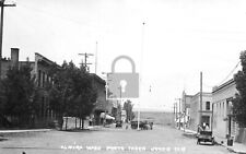
Street View Trolley Car Cosmopolis Washington WA Reprint Postcard $4.99

JUMBO VIRGINIA STATE MAP MAGNET 7 COLOR RICHMOND FREDERICKSBURG ALEXANDRIA $6.75
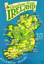
Map Greetings From Ireland Postcard $1.99

Thomas Jefferson Memorial National Park Unigrid Brochure Map Washington DC $5.99
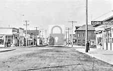
Street View Almira Washington WA Reprint Postcard $4.99

Antietam National Battlefield Park Unigrid Brochure Map NPS Maryland $2.89

Vietnam Veterans Memorial National Park Unigrid Brochure Map Washington DC $5.49

Nice Lot of 50~Mixed Vintage Antique Holidays Greeting Postcards~in sleeves-h805 $39.95

Huge 1500+ US & World Postcard Collection Lot Antique Vintage Early 1900s-1980s $199.95
|


)


