

|
Site Categories |
|
Featured Items |

Poodle, Spaghetti Trim, Ucagco


|
Allentown Vicinity, Pennsylvania Street Map by Franklin Maps For Sale


When you click on links to various merchants on this site and make a purchase, this can result in this site earning a commission. Affiliate programs and affiliations include, but are not limited to, the eBay Partner Network.

Allentown Vicinity, Pennsylvania Street Map by Franklin Maps:
$12.95
Allentown, Bethlehem, Easton, Pennsylvania Street Map by Franklin MapsIn Lehigh & Northampton Counties49½\" x 36\" (folded size is 4½ x 10)Street Level Detail. Zip Codes shown on map.All Township & Boroughs defined by color & Place Names marked on map.All streets indexed with Zip Codes.Western portion of county with Eastern portion on reverse side. Major Cities within the County: Allentown, Bethlehem, Easton, Dorney Park, Macungie, Emmaus, Coplay, Catasuqua, Slatington, Nazareth, Bath, Hellertown, Fountain HillState Game Lands, State Parks & Forests, Recreation Areas, Lakes-Rivers-Streams, Physical Features, Golf Courses, Colleges/Universities, & other Points of Interest.©2005, Scale: 1\"=2666\'(Multiple copies by request)
|
|
Related Items: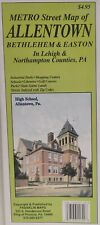
Allentown Vicinity, Pennsylvania Street Map by Franklin Maps $12.95
|
|
|
Shopping Cart  |

|
Recently Viewed |
|
Latest Items |
|
Facebook |
Secure Websites

|
