When you click on links to various merchants on this site and make a purchase, this can result in this site earning a commission. Affiliate programs and affiliations include, but are not limited to, the eBay Partner Network.
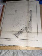
This antique 1867 US Map from the U.S. Coast Survey depicts Shilshole Bay in Washington Territory, before Washington became a state. A true piece of history, this collectible paper ephemera dates back to the 1800s and provides a unique glimpse into the past.
Trimmed on left bottom side, as pictured
All ephemera has wear commensurate to age, including, potentially: nicks, folds, smudges, rips at edges, stains, old smells, minor rips at folds , small holes, and other imperfections. Our research notes indicate our best efforts but are not guaranteed to be 100% accurate. You get what you see :)